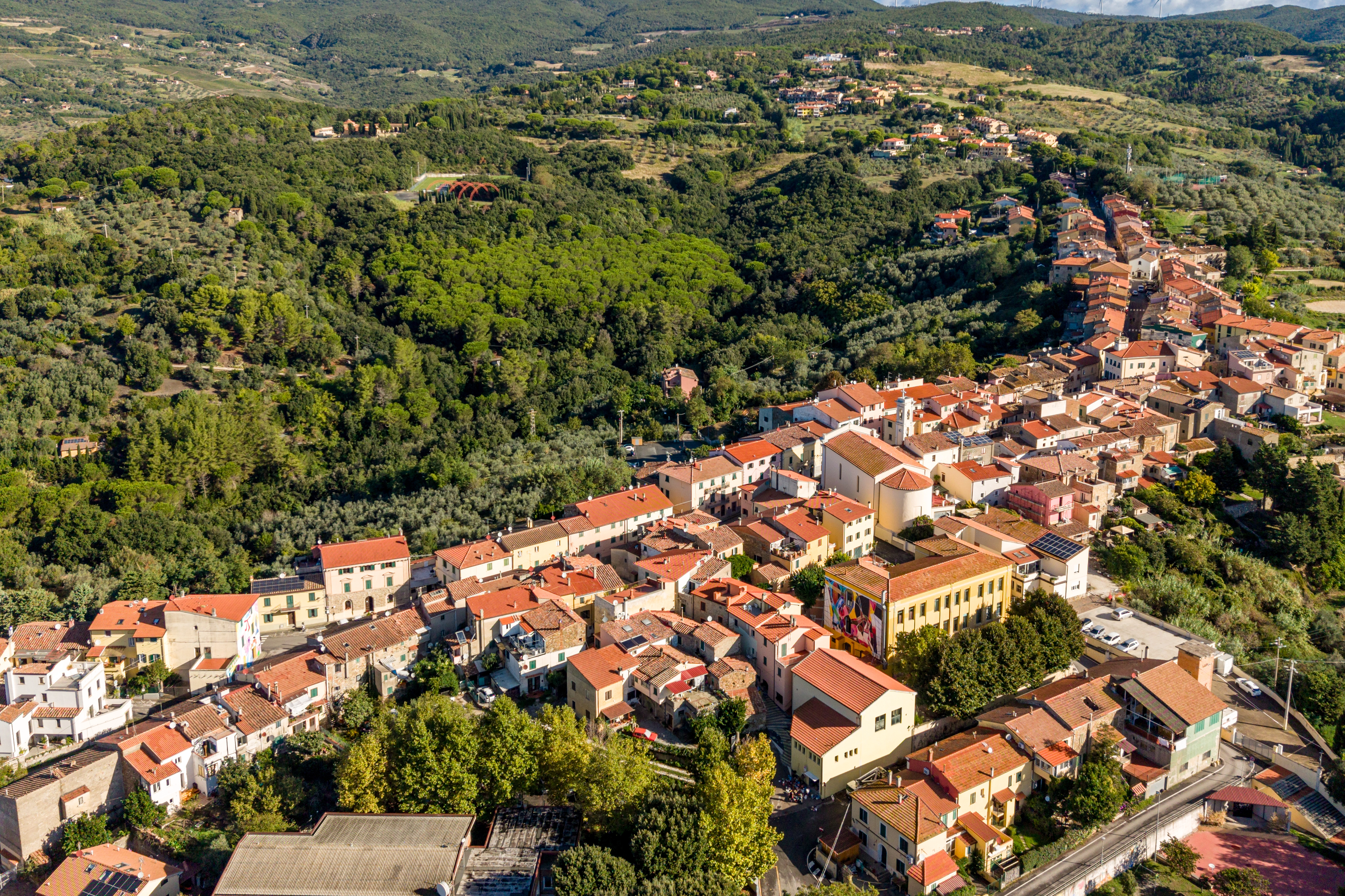
A hilltop town literally surrounded by green. Woods, Mediterranean scrub, panoramic trails, natural springs. Riparbella is best explored on foot, by bike or on horseback.
58.7 km²Municipal area
14Official routes
632Hectares of PAFR woodland
216 mElevation of the town
Riparbella looks out over the Val di Cecina
, on the first hills running down from inland towards the Tyrrhenian coast. From 216 metres up your eye reaches the sea and, on clear days, the islands of the Tuscan Archipelago.
The area is covered in coppice woodland, Mediterranean scrub, cork oaks, vineyards and olive groves. The Municipality has waymarked six circular trails
with red-and-white markers — more than 30 km, with information boards and descriptions in Italian and English — plus another seven bike & trekking routes
covering around 65 km, as well as the Anello del Vino wine loop linking the nine wineries.
At the heart of it all is the Giardino Scornabecchi
: 632 hectares of Regional Agricultural and Forestry Estate, recently certified FSC and PEFC
for sustainable forest management. Here you will also find the “Il Giardino Sospeso” adventure park and the land art installations of Paesaggi Cosmici.
The trails and green routes on the map
Loading the map of the town…
The map is open full screen.
The map failed to load. Try reloading the page.
Riparbellathe map of the town and its countryside
Tap a category above: the map adjusts and the list opens
Riparbella in practice
A medieval hilltop town stretched along a ridge of white tufa at 216 m above sea level, in the province of Pisa, between the Val di Cecina and the Etruscan Coast. It grows in a line along the ridge — not on a circular plan like the neighbouring towns — with 13 murals in the old town, nine wineries in the countryside and around 65 km of green trails.
Getting here
By car
Exit at Cecina Nord
on the SS1 Aurelia / Variante Aurelia, then SP 13 del Commercio
. Cecina 10 km (15′) · Livorno 50 km (45′) · Pisa 65 km (55′) · Volterra 35 km (40′) · Florence 130 km (1h 45′).
By train
The nearest useful station is Cecina
, on the Pisa–Rome Tyrrhenian line; from there you continue by bus, taxi or hire car. The Cecina–Saline di Volterra railway is not in service
and is replaced by buses: the San Martino stop is therefore not a useful arrival point.
By bus
Riparbella is served by regional bus routes with their terminus in Cecina: up-to-date timetables and stops at at-bus.it.
By bike
Anello del Vino
: 42 km and around 1,000 m of ascent taking in the nine wineries. Bike racks in the old town and e-bike charging points.
Car parks — all free
You can walk across the town in a few minutes: leave the car in one of the car parks along the ridge. On the map they are marked with the letters A–I
from south to north, and every card has a direct link to Google Maps.
A · Via delle Mura
— the first one you come to arriving from the south, from the coast.
B · Via Carlo Alberto Dalla Chiesa
— the lower part of the town and the Church of San Giovanni Evangelista.
C · Via della Fonte Vecchia
— the central car park.
D · Via degli Orti
— central area, a few steps from the Town Hall.
E · Via della Grotta
— the largest, on the north side: a flight of steps leads straight up to Piazza della Madonna.
F · Oliveta car park
— north side, along Via Roma.
G · San Rocchino
— next to the park and the tabernacle of San Rocco.
H · Cemetery area
— handy for the Monumental Cemetery.
I · Sports ground
— during festivals it is normally reserved for campervans.
The murals
There are 13 so far
: every year, on the last weekend in September
, the festival La Collina delle Fiabe
adds new ones. They are painted by international artists working with residents and with the owners of the walls, and each one tells a story about Riparbella or is connected to the town in some way. You can see them all on foot in half an hour, all in the old town, along with the twenty hand-painted artist benches
.
The project was started in 2018
by the municipal administration with the association StArt Attitude
and funding from the GAL Etruria, with the idea of turning the town into an open-air contemporary art museum. You can follow the route on your own with the map from the tourist office, or join a guided tour led by volunteers.
Useful numbers
Tourist office / Town Hall Piazza del Popolo 1 · 0586 697111
Ripa Fiorita — flowers and tradition. From May, Via di Piazzetta becomes the street of coloured umbrellas
24 June
Night of San Giovanni
July
Ripa Wine — wine and music
early August
Agrifiera
late August
RipaTalent
last weekend in September
La Collina delle Fiabe
— street art festival: the new murals are created
November
Sagra del Cinghiale wild boar festival · Festival of Tradition and New Olive Oil
December – January
RipaChristmas and the Mechanical Nativity Scene
How to use the map
Tap a category at the top
: the map frames those points and the list opens.
In the old town, points close together are grouped into a circle with a number
: tap it to open it.
On every card the button Take me there
opens navigation in Google Maps.
With the crosshair
button, top right, you can see where you are in relation to the points on the map.
Data sources
Content from the Riparbella tourist office and the portal visitriparbella.com, data from the BiciInComune
app and base mapping by OpenStreetMap. The car park locations are those given by the tourist office. Some points in the centre have a position estimated along the street from the house number: their card says so.
The marker shows the starting point
of each route. Tap a point for its length, ascent and directions in Google Maps; the full descriptions, with tracks to download, are below.
«Between hills covered in olive trees and the sea in the background, the Tuscan rural landscape in its most authentic form.
»
How to explore
Four ways to enjoy them.
There are many ways to travel Riparbella’s green spaces. Choose your own pace: contemplative, sporty, with the family or with the wind in your hair.
On foot
Trekking & walking
Six circular trails waymarked in red and white, from 3.4 to 7.8 km, plus the trekking routes in the Giardino and the one to Miemo. Difficulty from easy to medium+, one for every pair of legs.
In the saddle
Mountain bike
Seven circular routes among gravel roads, woods and vineyards, from the 3.8 km of the washhouses loop to the 46.6 km of the Anello del Vino
linking the nine wineries of Riparbella.
On horseback
Riding trails
The gravel roads and scrubland paths can also be ridden: in the area there are riding centres and farm stays with horses
that organise rides in the woods.
With a guide
Guided experiences
Green Riders Experience
(Kitewell ASD), based at the Giardino, organises e-bike excursions, wine trekking between the wineries and the free MTB Experience course for young people and families.
The 14 official routes
Mapped by the Municipality
, described step by step.
Six circular trails waymarked in red and white, seven bike & trekking routes and the Anello del Vino. For each one you will find the track on the map, the official data and the full description by the Municipality of Riparbella, in Italian and in English on the municipal website.
Circular, waymarked in red and white and with information boards along the way: five start from the town, one runs inside the Giardino Scornabecchi.
Difficulty · Easy
Trail no. 1
Ripa Bella
A pleasant walk around Riparbella and through the old town, past characteristic corners and curiosities. The route starts from the shrine dedicated to San Rocco at the entrance to the town.
A walk along the panoramic road up to the spring and onto the hilltops, among cork oaks and green rocks. We start with the cemetery of Riparbella on our left and follow for about 2 kilometres the road that climbs gently along the hillside.
A walk to get to know — and recognise — the plants of our woods. We start from the clearing known as the «basto a rovescio» and follow the path lined with tree heather. 1.
A route through woods and old farmsteads, in places that bear witness to a past of everyday life and to the tragic events of the last century. We start from Lo Smorto, site of the Riparbella wind farm, and go down towards «Strido» along the old Via Chiannerina.
Trekking through the gorges of the Rialdo stream, on the traces of ancient settlements and over stony hilltops where life adapts to a wild environment. Along the old Via Chiannerina, past the hamlet of San Pecoraio, we find on the right a widening in the road with a fine Turkey oak in the middle.
A circular trail in the «Il Giardino» wildlife and forestry estate, among old trees to hug, the little waterfall with its warm spring and the educational paths deep in the scrub. The route runs inside the protected area of the «Giardino» and starts from the estate centre.
Around 65 km across the Regional Agricultural and Forestry Estate, the countryside around the town and the neighbouring areas: they can be walked and, almost all of them, cycled.
Difficulty · Easy
Bike & trekking route
The old washhouses loop
A circular trail that can be walked or cycled in the woods around the town of Riparbella. Start and finish: the central bar of Riparbella in Piazza Matteotti.
A circular trail that can be walked or cycled from the town of Riparbella, along the road leading to some important wineries. Start and finish in the town centre, climbing to the upper part of the hill at San Pecoraio.
A circular trail that can be walked or cycled from the town of Riparbella towards Nocolino and into the woods at Ortaicavoli. It starts in Riparbella in Via Roma, in front of the old slaughterhouses; continue along Via del Commercio towards Castellina as far as Nocolino; from there go down the Ortaicavoli consortium road, turn at the junction for the Le Debbiare farm stay and carry on to Il Badalo, where you will find the villa of the Olympic cycling champion Paolo Bettini.
A circular trail that can be walked or cycled in the woods at Il Giardino. The loop starts from the lower part of the Regional Agricultural and Forestry Estate and, along a route entirely immersed in the scrub, reaches a botanical circuit where dedicated signs point out the different species of flora and fauna typical of the Mediterranean scrub.
A circular trail that can be walked or cycled in the woods at Il Giardino. A route deep in the woodland where enduro fans will find some interesting sections.
The only itinerary that leaves the municipality: it starts at the wind turbines of Riparbella and goes on foot as far as the hamlet of Miemo, in the Val di Cecina. It is the road that the children of Riparbella took after the war
to get to primary school, and along the way you may meet fawns and wild boar.
The great cycling loop of the area: it starts from the woods at Il Giardino and links all the wineries of Riparbella, among hills, vineyards and glimpses of the sea. It was designed by the association Green Riders Experience
: nine stops, tastings at every winery and the chance to book a zero-food-mile show-cooking lunch.
The six «Sentieri di Riparbella» are marked with the classic red-and-white signs
and have information boards along the way. The bike & trekking loops follow gravel roads and paths: it is best to download the GPX before setting off.
Equipment
Walking boots
Footwear suited to the ground, especially after rain. Water, snacks and a hat
in summer, a windproof jacket in winter. For the longer trails a rucksack is recommended.
Info point
Pro Loco Tourist Office
Piazza del Popolo, in the old town: trail maps, guided tours of the murals and information about events and routes. prolocoriparbella@gmail.com
· visitriparbella.com
Access
Free · All year round
The trails are free to use. The Giardino Scornabecchi is always accessible; the adventure park has seasonal opening hours.
A pleasant walk around Riparbella and through the old town, past characteristic corners and curiosities.
Technical details
Length3.4 km
Ascent105 m
DifficultyEasy
Type of userTrekking
LayoutCircular: start and finish at the same point
The route, step by step
The route starts from the shrine dedicated to San Rocco at the entrance to the town. Taking Via del Commercio towards Castellina, we reach the charming monumental cemetery 1
an early work by the architect Luigi Bellincioni (1894). We carry on along the little road lined with cork oaks, which crosses the district of I Fornelli.
From here we go down and, at the fork, turn left. The route now offers a fine view over the countryside and over the town of Riparbella 2
with its distinctive elongated shape. We follow the road, leaving a farm track on our right and, having crossed a small wood, climb back towards the centre along Via della Fonte Vecchia.
As we approach Piazza Borgo di Sotto, we come to the first murals 3
which we can admire as we follow the route through the town lanes, where we also pass the Municipal Library. This is home to «C’ERA»: a small but interesting exhibition centre about ancient Riparbella. Crossing the oldest core of the town we come to the war memorial, the Oratory of the Madonna delle Grazie and that of the SS Annunziata, today home to the distinctive hand-made mechanical nativity scene 4. We carry on along the main street until we are back at our starting point.
Official data and description from the Municipality of Riparbella. The track on the map is the GPX published on Costa degli Etruschi: use it as a reference, not as exact navigation, and always follow the signs on the ground.
A walk along the panoramic road up to the spring and onto the hilltops, among cork oaks and green rocks.
Technical details
Length8 km
Ascent256 m
DifficultyMedium
Type of userTrekking
LayoutCircular: start and finish at the same point
The route, step by step
We start with the cemetery of Riparbella on our left and follow for about 2 kilometres the road that climbs gently along the hillside. Our eye ranges over the characteristic Tuscan rural landscape 1
with the sea in the background. Having crossed a small bridge over the Le Botra stream, we go down the steps to reach the «spring at the wooden bridge» 2
whose water is sweet-tasting and rich in magnesium.
After a few metres we leave the road and turn right, climbing the path up Poggio Il Gabbrone. Here we make a short detour to reach a fine cork oak «stump» 3. Retracing our steps we carry on along the path into the woods and, after crossing a few tracks, reach trail no. 3, which we follow by turning right.
After crossing a striking outcrop of «green rocks» 4
, we reach the clearing known as the «basto a rovescio» and from there, following the panoramic Via Chiannerina, we go back down to our starting point.
Official data and description from the Municipality of Riparbella. The track on the map is the GPX published on Costa degli Etruschi: use it as a reference, not as exact navigation, and always follow the signs on the ground.
A walk to get to know — and recognise — the plants of our woods.
Technical details
Length5.3 km
Ascent110 m
DifficultyEasy
Type of userTrekking
LayoutCircular: start and finish at the same point
The route, step by step
We start from the clearing known as the «basto a rovescio» and follow the path lined with tree heather 1. Having crossed the brook that runs between the «green rocks», the woodland grows taller and we meet the first old oaks, holm oak and Turkey oak. We leave trail no. 2 on our left and climb until we reach a level track through the high forest.
We turn right and stop to admire a specimen of Cerrosughera 2
, a natural hybrid of Turkey oak and cork oak considered very rare. Leaving the wood, we cross grey, stony ground with its characteristic flora of spiny spurge «cushions» 3. We carry on and cross trail no. 4 of the «Percorsi verdi di Castellina», which we leave on our left.
Having crossed the large clearing of «Campo a Quaranta», we turn left, following the signs, and take the track that skirts Poggio del Malconsiglio and crosses an area of «coppice woodland» 4
and brings us to «Lo Smorto», site of the Riparbella wind farm. Here we turn right and, following the old Via Chiannerina, return to our starting point.
Official data and description from the Municipality of Riparbella. The track on the map is the GPX published on Costa degli Etruschi: use it as a reference, not as exact navigation, and always follow the signs on the ground.
A route through woods and old farmsteads, in places that bear witness to a past of everyday life and to the tragic events of the last century.
Technical details
Length6 km
Ascent200 m
DifficultyMedium +
Type of userTrekking
LayoutLinear: start and finish at different points
The route, step by step
We start from Lo Smorto, site of the Riparbella wind farm, and go down towards «Strido» along the old Via Chiannerina. On reaching Podere Le Marie, we stop at the memorial stone 1
raised in memory of the massacre carried out by the Nazis on 25 June 1944. We carry on to the «Il Pantano» farm, leave the road and turn left along the main track, which crosses several paths and follows the line of an aqueduct.
Reaching the bed of the Sterza stream, we cross it and climb the steep path that brings us to the «Gusciane» farm 2
by now completely covered in ivy. We carry straight on to the edge of the old field and here turn left onto the descending path. After a few metres, on the left, we find the detour to visit the ruins of the old watermill 3.
Retracing our steps we carry on until we meet trail no. 4 of the «Percorsi Verdi di Castellina», which we follow for a stretch, turning left. After stopping near the picturesque «little waterfall» 4
, we carry on for a few hundred metres; we leave the «Percorsi Verdi» on our right and take the descending path. Here we cross several tracks but carry on until we find, on our right, the signs for the path that climbs into the woods.
Along this stretch the ground is scoured by water, so a certain effort is required. At the top of the climb we find trail no. 3, which we follow by turning left until we are back at our starting point.
Official data and description from the Municipality of Riparbella. The track on the map is the GPX published on Costa degli Etruschi: use it as a reference, not as exact navigation, and always follow the signs on the ground.
Trekking through the gorges of the Rialdo stream, on the traces of ancient settlements and over stony hilltops where life adapts to a wild environment.
Technical details
Length7.8 km
Ascent273 m
DifficultyMedium +
Type of userTrekking
LayoutLinear: start and finish at different points
The route, step by step
Along the old Via Chiannerina, past the hamlet of San Pecoraio, we find on the right a widening in the road with a fine Turkey oak in the middle. Our route starts here. We follow the path down into the woods and, after about a kilometre, cross a small brook, then climb to a clearing where a wide path joins from the left, which we leave behind.
Following the signs we take the path that leads us into the gorges of the Rialdo stream 1. Having crossed it, we climb back into the woods following the red-and-white markers and come to the «Chiesaccia» area where, with a detour, we can reach the site of the ancient Castello di Mele 2. Back on the main route we carry on uphill to the «Leccino» and from there reach the slopes of Poggio Bianco, where another short detour lets us admire the fine view and some oaks that have become «natural bonsai» 3.
Back on the main route we carry on to the Val di Lopia country lane. We turn left and climb into the wind farm area. Look carefully and you can spot the «great face» carved into the rock 4.
At the «Lo Smorto» crossroads we turn left and go down the road to our starting point.
Official data and description from the Municipality of Riparbella. The track on the map is the GPX published on Costa degli Etruschi: use it as a reference, not as exact navigation, and always follow the signs on the ground.
A circular trail in the «Il Giardino» wildlife and forestry estate, among old trees to hug, the little waterfall with its warm spring and the educational paths deep in the scrub.
Technical details
Length7 km
Ascent112 m
DifficultyMedium
Type of userTrekking
LayoutLinear: start and finish at different points
The route, step by step
The route runs inside the protected area of the «Giardino» and starts from the estate centre. We cross the large equipped area next to the adventure park and enter the woods until we reach the former fire pond. We carry straight on along the level track that follows the course of the Botro il Bagnolo, leaving on our right the track through the Carpineta, to be used as an alternative if the stream is in spate.
In this area, thanks to the presence of large trees, we can practise forest therapy 1
: hug a tree and feel better at once. We carry on and, looking carefully, discover a great many fossil shells in the ground 2. We follow the course of the stream, crossing it several times, and reach the Cascatoio 3
: a striking corner of nature with a warm spring and a small waterfall coming down from the «green rocks» above.
From here we climb an earth stairway and follow the path that runs for a few hundred metres along the boundary of the protected area. We turn left, following the signs, and take the path that crosses the scrub among myrtle and mastic bushes. At «Il Mottaio» we leave the wide gravel track on our right and follow the path that runs alongside an old fence.
After crossing a small stream we climb up to «La Pineta». We cross the country lane and visit the Botanical Trail 4. We go down into the woods and, after turning left, follow the path alongside the Acquerta stream until we come to a small Educational Trail 5
which shows us the animals living in this area. We walk the avenue of holm oaks back to our starting point.
Official data and description from the Municipality of Riparbella. The track on the map is the GPX published on Costa degli Etruschi: use it as a reference, not as exact navigation, and always follow the signs on the ground.
Bike & trekking route · Trekking and cycle touring
The old washhouses loop
A circular trail that can be walked or cycled in the woods around the town of Riparbella.
Technical details
Length3.80 km
Ascent238 m
DifficultyEasy
Type of userTrekking and cycle touring
Surfaceasphalt and gravel road
ViewpointsYes, along the route
LayoutCircular: start and finish at the same point
When to do itRoute open all year round
The route, step by step
Start and finish: the central bar of Riparbella in Piazza Matteotti. From the bar we carry on along Via del Commercio to the monumental cemetery, where a track begins deep in the woods, typically marked by the flora and fauna of the Mediterranean scrub. The route is an old path used in the early 1900s by Riparbella families to wash their «laundry» in the municipal washhouses (hence the name of the trail).
What makes this route special is that it keeps you in the heart of the town while taking you into the woods. Recommended for anyone who wants a quick walk surrounded by the green of the Mediterranean scrub.
Points marked along the track
Commemorative cypresses
Viewpoint
Mimosas
Official data and description from the Municipality of Riparbella. The track on the map is the GPX published on Costa degli Etruschi: use it as a reference, not as exact navigation, and always follow the signs on the ground.
Bike & trekking route · Trekking and cycle touring
The Serra all’olio loop
A circular trail that can be walked or cycled from the town of Riparbella, along the road leading to some important wineries.
Technical details
Length9.80 km
Ascent338 m
DifficultyMedium/Easy
Type of userTrekking and cycle touring
Surfaceasphalt, gravel road and small paths with uneven ground
ViewpointsYes, along the route
LayoutCircular: start and finish at the same point
When to do itRoute not recommended during the wild boar hunting season, from 25 November to 31 January
The route, step by step
Start and finish in the town centre, climbing to the upper part of the hill at San Pecoraio. Along the route we pass three of Riparbella’s most important wineries: Caiarossa, La Cava and Prima Pietra. The view as you come down the hill back into the town centre is unforgettable, taking in the islands of the Tuscan Archipelago.
Official data and description from the Municipality of Riparbella. The track on the map is the GPX published on Costa degli Etruschi: use it as a reference, not as exact navigation, and always follow the signs on the ground.
Bike & trekking route · Trekking and cycle touring
The Ortaicavoli loop
A circular trail that can be walked or cycled from the town of Riparbella towards Nocolino and into the woods at Ortaicavoli.
Technical details
Length11.78 km
Ascent322 m
DifficultyEasy
Type of userTrekking and cycle touring
Surfaceasphalt and gravel road
LayoutCircular: start and finish at the same point
When to do itRoute not recommended during the wild boar hunting season, from 25 November to 31 January
The route, step by step
It starts in Riparbella in Via Roma, in front of the old slaughterhouses; continue along Via del Commercio towards Castellina as far as Nocolino; from there go down the Ortaicavoli consortium road, turn at the junction for the Le Debbiare farm stay and carry on to Il Badalo, where you will find the villa of the Olympic cycling champion Paolo Bettini. The beauty of the Mediterranean scrub will surprise you with breathtaking glimpses of landscape.
Points marked along the track
Casa Bettini
Caiarossa
La Cava
Official data and description from the Municipality of Riparbella. The track on the map is the GPX published on Costa degli Etruschi: use it as a reference, not as exact navigation, and always follow the signs on the ground.
Bike & trekking route · Trekking and cycle touring
The botanical loop
A circular trail that can be walked or cycled in the woods at Il Giardino.
Technical details
Length4.80 km
Ascent338 m
DifficultyEasy
Type of userTrekking and cycle touring
Surfacegravel road and small paths with uneven ground
ViewpointsYes, along the route
LayoutCircular: start and finish at the same point
When to do itRoute open all year round
The route, step by step
The loop starts from the lower part of the Regional Agricultural and Forestry Estate and, along a route entirely immersed in the scrub, reaches a botanical circuit where dedicated signs point out the different species of flora and fauna typical of the Mediterranean scrub.
Official data and description from the Municipality of Riparbella. The track on the map is the GPX published on Costa degli Etruschi: use it as a reference, not as exact navigation, and always follow the signs on the ground.
A circular trail that can be walked or cycled in the woods at Il Giardino.
Technical details
Length9.80 km
Ascent228 m
DifficultyMedium/Easy
Type of userCycle touring
Surfacegravel road and small paths with uneven ground
ViewpointsYes, along the route
LayoutCircular: start and finish at the same point
When to do itRoute not recommended during the wild boar hunting season, from 25 November to 31 January
The route, step by step
A route deep in the woodland where enduro fans will find some interesting sections. A beautiful track that passes through the vineyards of Papi–Pakravan, one of Riparbella’s most prestigious wineries.
Points marked along the track
Snowdrops
Hellebore
Bay laurel
Ivy
Cork oak
Butcher’s broom
Strawberry trees, myrtle, mastic
Wormwood
Maidenhair fern
Edible herbs
Official data and description from the Municipality of Riparbella. The track on the map is the GPX published on Costa degli Etruschi: use it as a reference, not as exact navigation, and always follow the signs on the ground.
A circular trail that can be walked in the woods at Il Giardino.
Technical details
Length10.6 km
Ascent448 m
DifficultyMedium
Type of userTrekking
Surfacegravel road
ViewpointsYes, along the route
LayoutLinear: start and finish at different points
When to do itThe area is used for hunting, so from 1 October to 31 January it is advisable to use the routes only on Tuesdays and Fridays, when hunting is always closed.
The route, step by step
A walk inside the Giardino Scornabecchi. The path takes you along a botanical trail that leads to the beautiful Cascatoio, where there is also a spring you can reach along a wooden walkway. There is a rest area with tables and benches where you can take in the sight and the sound of the falling water.
In winter the waterfall is at its most splendid and powerful. Along the way you may meet animals typical of the Riparbella countryside: fawns, fallow deer and wild boar.
Points marked along the track
Cascatoio waterfall and warm spring
Official data and description from the Municipality of Riparbella. The track on the map is the GPX published on Costa degli Etruschi: use it as a reference, not as exact navigation, and always follow the signs on the ground.
A walking route starting from the Riparbella wind farm and finishing at the hamlet of Miemo.
Technical details
Length14.16 km
Ascent529 m
DifficultyMedium
Type of userTrekking
Surfaceasphalt, gravel road and small paths with uneven ground
ViewpointsYes, along the route
LayoutCircular: start and finish at the same point
When to do itRoute open all year round
The route, step by step
A walk from the Riparbella wind farm to Miemo. The path takes you through a wonderful landscape, all the way to the beautiful, characterful little hamlet of Miemo with its lovely gardens. You are retracing the walk the children of Riparbella made just after the war to reach the primary school in Miemo.
Along the way you may meet animals typical of the Riparbella countryside, such as fawns and wild boar
Official data and description from the Municipality of Riparbella. The track on the map is the GPX published on Costa degli Etruschi: use it as a reference, not as exact navigation, and always follow the signs on the ground.
A cycling loop that starts from the woods at Il Giardino and takes you round the 9 wineries of Riparbella.
Technical details
Length46.60 km
Ascent410 m
DifficultyMedium/Easy
Type of userCycle touring
Surfaceasphalt and gravel road
ViewpointsYes, along the route
LayoutCircular: start and finish at the same point
The route, step by step
Created by the Green Riders Experience association, a route on which you can immerse yourself in nature, among hills and sea views, arriving at the wineries of Riparbella, which open their doors to reveal knowledge and flavours born of a tradition that blends with innovation spontaneously and naturally. 9 stops, with the chance to book a show-cooking lunch based on healthy, zero-food-mile cooking, and tastings at every winery with Riparbella produce and its wines centre stage. A day of flavour and beauty.
Points marked along the track
Papi winery
Papi winery
Duemani vineyard
Quercialuce winery
La Regola winery
Riparbella town
La Cava winery
Caiarossa winery
Urlari winery
Urlari winery and vineyards
Colline Albelle winery
Wind turbines viewpoint
Prima Pietra winery
Official data and description from the Municipality of Riparbella. The track on the map is the GPX published on Costa degli Etruschi: use it as a reference, not as exact navigation, and always follow the signs on the ground.